
Change is real, it requires work, and we must understand that it’s a process. The most noticeable change resulting from this innovative experiment is the shift in the policymakers’ mindset, especially at the local (municipal) level. The Municipality of Centar has an important role in development of sustainable City of Skopje by making appropriate decisions on urban and environmental planning:
– Planning urban space to achieve balanced urban growth while respecting fundamental rights for: accessible housing for all citizens; supporting the underdeveloped and poor community with improving access to the labor market; access to basic communal and social services, providing infrastructure for every citizen.
– Achieve a balanced and coherent city morphology by planning and implementing inclusive and sustainable policies supported with proper financial management in order to:
· utilize available resources for better economic management
· protect the public good and natural resources (improve climate resilience)
· risk assessment and mitigation (especially climate change relevant disaster risk reduction activities);
Modus operandi of the Centar municipality in achieving SDG goals:
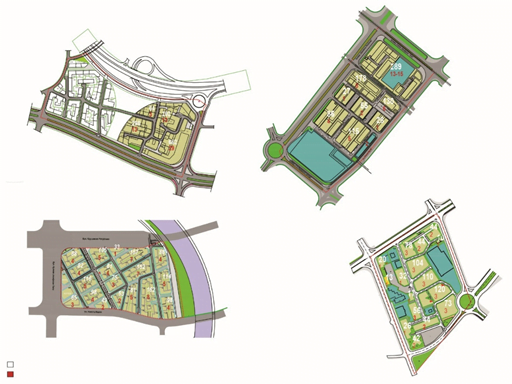
1. Revision of the urban plans in Skopje (so-called moratorium)
2. Improving, enhancing and amplifying green spaces within the urban environment.
3. Reducing and removing the number of cars and parking lots, and further conversion of these spaces into greenery or public spaces
4. Provide more public spaces whilst improving safety, cleanliness and overall quality.
This is possible with an inclusive approach involving all groups, communities or citizens, as no one should be left behind and everyone is important.
The Republic of North Macedonia has signed many declarations to achieve urban sustainability, including UNDP’s Sustainable Development Goals (SDGs).
SDG Goal 11 precisely relates to these measures such as public participation in sustainable development and planning, quality of air and overall wellness, as well as freely available green public spaces. It is exactly for this reason we pay close attention to policy making.
Data as baseline for Sustainable Urban Planning and Development
Indicators and parameters require accurate, updated and verified data, which mostly lack in spite of the good spirit to gather data to promote our society within internationally established frameworks. Moreover, a large scope of relevant data is missing or is unavailable. To find the indicators for urban development and sustainability in our local context, a methodology was developed that shows the level of sustainability and the opportunities to introduce new measures. These indicators and parameters were considered as recommended not only by UN’s SDGs, but also by the EU indicators for Sustainable Cities.
Starting the research with limited data, a mapping process was initiated by using different types of modeling applications to evaluate the city quarters concerning the SDG indicators. Our small team believed that progress comes after research where data is crucial for improving the decision-making process.
Citizens also request identical improvements as stated in the sustainable goals, suggesting to go hand in hand with the public because public support plays the most valuable asset in processes where institutional aid is insufficient. Protecting the environment as well as confronting pollution are the top priorities for the wellbeing and the quality of life for the citizens. This is a uniting problem and it requires us to be on the same side working together. It that sense, the public has contributed greatly with actions and campaigns such as “Ne bidi gjubre” (Don’t be garbage) in spreading awareness about pollution and the low quality of the urban blocks and the surrounding landscape, and the work of the O2 organization in informing about and improving the air quality in the city.

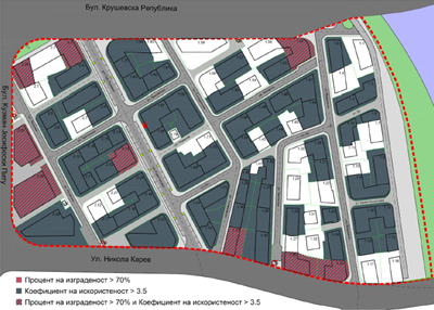
Despite our actions, the latest research renders poor results. Firstly, the social and developmental injustice and inequity in the urban region is dramatic — an imbalanced urban growth. Secondly, the absence of green infrastructure and green areas. Thirdly, no evident or very little effort in optimizing public and sustainable transport to stimulate more users to walk, bike and use the public transport. Unexpectedly, some urban areas, in the Center municipality, suffer from the lack of fundamental basic infrastructure such as sewers. These poor conditions contributed to an overall polluted settlement, and as pollution recognizes no boundaries, it affects both those in highly developed areas just as those in appalling neighborhoods. Lastly, the challenge is how to add a plan of action to eradicate these negative side-effects that did not exist in the folders of the local government.
So, where do we stand today? Are we going uphill or downhill?
From promises to realizations? What is the plan of action?
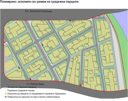
The current numbers show that the vector of indication is going down. For example, the urban greenery and green spaces were not calculated and documented, and there is no statistical evidence whether we are improving or worsening this situation. As a response, a new plan proposes that greeneries will be documented, evaluated and thereafter registered in a GIS database.
Subsequently, traffic analysis have not been made until today, but now it has been proposed as a regulation that such analysis will serve as criteria for further policy-making and design interventions. In another case, the urban saturation of dwellers has over passed the recommended limits, and this demonstrates that the local government has paid very little attention to these types of measures from the general plan. In answer to this identified challenge, a revision has been started to correct all detailed plans that go outside the limits of the general plan in terms of urban density.
Mitigation measures is essential but what’s lacking is local inspection. The deficiency of active local inspection is quite obvious because construction companies act as if no rules and regulations need to be provided. This includes safeguarding the building plot to avoid injuring passengers walking by, or providing the necessary equipment when demolishing a building due to dust and debris. Furthermore, new buildings do not suffice the required amount of parking spaces per apartment and oftentimes apartments are sold without obliging the purchaser to secure a parking space inside the building. Additionally, many approved buildings step out of the approval permits resulting in massive disturbance of pavements, parks and public space, reduced safety for pedestrians and all other non-motorized traffic users. Lastly, new construction activities do not respect the minimum required percentage of greenery, leaving the city devastated due to the lack of green areas.
The new law on urban greenery compliments and aids this process in achieving the SDG. The law itself determines the criteria of percentage on two scales, first on the overall plan and second in an individual parcel. For individual parcels, the minimum required greenery is 20% out of the overall built space. Regardless of this obligation, in praxis, many new buildings do not meet this criteria. A very dramatic finding in some of the urban plans that have been paused is that green areas and parks have been converted into plots suitable for buildings, which automatically makes it impossible for the general urban plan to meet its demand — 25 m² green area per person.
All of this has led to the actual decision of putting current urban plans in pause, or under the so-called moratorium. In other words, further issuing of building permits on current urban plans has been banned, until the plans in question are revised, improved and initiated. In the process, the public has been greatly involved and the results are starting to be visible.
The evaluation methodology was designed by a team of experts, including professors from the Faculty of Architecture. Primarily, a list of priorities has been commissioned to determine the least and the most affected detailed plans, and thus, to strategically work in its accordance. Our ambition in this process was for the whole procedure to be public, transparent and inclusive. This concept stimulated public awareness and public participation, and at its best, created a new condition by which the citizens understood their role in policy making and urban development.
***
UNDP used the Skopje Lab platform to partner with the Faculty of Architecture, the Municipality of Center, experts and field researchers to test the methodology for measuring the SDG 11.7.1.
Indicator: “Average share of the built-up area of cities that is open space for public use for all, by sex, age and persons with disabilities”.
The research and piloting have been undertaken as part of the “Measuring the Unmeasured/Venturing Into the Unknown: How Can We Measure SDG Tier III Indicators?” Cross-Regional Project led by UNDP Regional Hubs in Istanbul, Aman and Bangkok. The project is supported through the UNDP Innovation Facility 2017, which is funded with a generous contribution of the Danish
Government.

